


i-Boating
Marine Navigation

Description of i-Boating: Marine Navigation
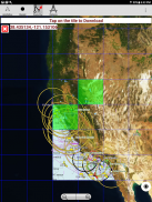
i-Boating: Marine Navigation is a mobile application designed for maritime navigation, offering users access to a variety of nautical charts, inland river navigation charts, and lake contour maps. This app is available for the Android platform, allowing users to download it for easy use on their devices. The application aims to assist boaters, anglers, kayakers, and sailors by providing essential navigation tools and features.
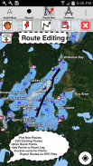
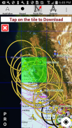
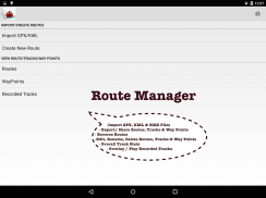
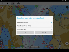
The app supports offline nautical charts, which enable users to navigate even without an internet connection. i-Boating includes detailed lake depth maps with safety contours, making it suitable for fishing and recreational boating. Users can create and manage boat routes and waypoints, making trip planning straightforward. The application allows for the import of existing GPX and KML files, which helps in integrating pre-planned routes into the app.
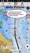
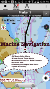
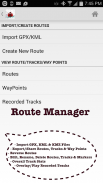
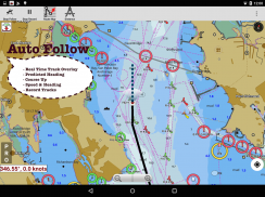
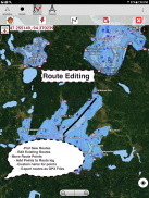
In terms of route management, i-Boating offers capabilities for creating, editing, and reversing boat routes. It facilitates the management of waypoints and allows users to share or export routes, boating logs, tracks, and markers. The app provides real-time overlay and predicted path vector features, which enhance navigation accuracy. The course-up orientation feature ensures that users can view their navigation direction clearly.
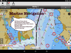
Voice prompts are a significant feature of i-Boating, providing route assistance to users while they navigate. The app alerts users when they approach boating route markers and provides real-time nautical distance and estimated time of arrival (ETA). Alerts for sailing or boating off route help to maintain safe navigation practices. Additionally, users can record their tracks, which allows for easy referencing of previous journeys.
The app incorporates tidal and current information, offering predictions for high and low tides as well as tidal currents. This feature is essential for boaters who need to be aware of changing water conditions that can affect their navigation. Marine weather updates are also included, utilizing GFS and ECMWF data to provide users with relevant weather information.
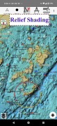
For those interested in fishing, i-Boating includes features such as fishing hot spots AI and lake temperature maps, which are accurate to 1°F (0.5°C). This information can significantly enhance the fishing experience by helping users identify the best locations and times to fish. The app also provides relief shading, which helps users understand the underwater topography of lakes and rivers.
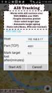
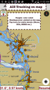
Instrumentation within the app includes support for Marine AIS (Automatic Identification System) and NMEA data through TCP/UDP connections. This feature allows users to access real-time information about other vessels in the vicinity, enhancing situational awareness. Wind direction and speed, as well as water temperature, can also be monitored through the app, providing users with a comprehensive view of their navigation environment.
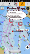
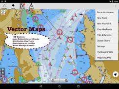
i-Boating covers a wide range of geographical areas, including the United States, Canada, the UK, Germany, France, and various regions within Europe. The application includes detailed maps that feature NOAA marine charts, ENC (Electronic Navigational Charts), and USACE inland river maps, ensuring that users have access to accurate and up-to-date navigation information.
The app's user interface is designed to be intuitive and user-friendly, making it accessible for both novice and experienced boaters. Features such as magnifying text and icons provide users with the ability to customize their viewing experience, enhancing usability on the water. The app supports offline functionality, which is particularly beneficial for users who may venture into areas with limited cellular service.
As a comprehensive marine navigation tool, i-Boating: Marine Navigation ensures that users have the necessary resources for safe and effective boating experiences. By combining various features such as route management, weather updates, and fishing information, the app serves as an all-in-one solution for mariners. The ability to download the app on Android devices allows for convenient access to vital navigational tools.
With seamless marine chart quilting, the application provides users with detailed information from coastal, approaches, harbor, and inland ENC charts. This extensive coverage ensures that boaters are well-informed of their surroundings, which is crucial for safe navigation. The high-definition depth maps and safety contours allow users to navigate with confidence, minimizing the risks associated with boating.
The app's continuous updates for one year ensure that users receive the latest information and features, keeping their navigation tools current. i-Boating: Marine Navigation stands out as a valuable resource for anyone involved in maritime activities, offering a blend of functionality and ease of use that enhances the boating experience.
i-Boating:Marine Navigation - Version 263.0
(03-05-2025)
i-Boating: Marine Navigation - APK Information
APK Version: 263.0Package: com.skiracer.nautical_astore_liteLatest Version of i-Boating:Marine Navigation
Other versions


Apps in the same category


